
Urban Wander
Local discovery and connection in Rathmines, Dublin through a walking app experience.
Role:
UX Designer, UI Designer, Researcher
Year:
2021
Overview
Walking is proven to be great for both physical and mental health. It is also an excellent way to explore and discover an urban environment, build a connection to a locality and create a sense of place. In this research project, a walking app experience was created to help a local community continuously discover and explore the Rathmines and surrounding area in Dublin.
The problem
Rathmines is a great place to walk through and around, but when I was seeking to explore new routes within the Rathmines area after initial routes had become exhausted and boredom set in, I wondered whether there was a possibility for technology to assist in this. Apps such as Google Maps are designed to get you from A to B as quickly as possible. Exercise Apps are designed to measure fitness productivity but there wasn’t such an app that encouraged the exploration of local overlooked history and culture through walking.
The opportunity
This research project therefore set out to explore if technology can help connect locals to the Rathmines area and help them discover more about the locality through walking.
The process
Lean UX: Think, Make, Check


Think
Literature Review
By examining the benefits walking has in everyday life and how walking can shape our connections to urban space, I established how psychogeography could be used to challenge dominant narratives of commercial, transient cityscapes. By creating opportunities for people to wander through their urban environment, and to encourage a multi-sensory experience of their surroundings, there is a potential for ‘place based learning’ and a building of a sense of connection and identity to local urban space through walking.
However It is apparent that the more popular technology offerings for walking through urban space do not allow for self-discovery of space. This is inhibiting a person’s ability to connect and build a sense of identity with their local environment and build a sense of connection to others. Crowdsourced technology with visual and audio content, shows a potential for technology to be used to reframe how locals see and connect to urban space.

Research question
How might we develop a walking app to help people living in the Rathmines area discover more about the locality, maintain engagement and build connections to other locals?
Initial user assumptions
1. People are walking more in the area due to Covid-19 and working from home.
2. People mostly walk for recreation.
3. People walk in the area a few times a week.
4. People have a relatively low sense or knowledge of the local history.
5. The Rathmines area is a transient community and as such, connection to other locals is quite low.
6. People use Google maps and exercise apps on their walk.


Surveys
Quantitative research in the form of a survey was compiled using Microsoft Forms, as it is easy to use and provides simply understood visuals for the results of each question. Respondents where sourced through local Rathmines and Rathgar Facebook groups, and respondents were asked to give their responses anonymously, so as to maintain privacy and ensure non-bias in the analysation of data. Out of approximately 300-400 members of the Facebook group, a total of 51 people responded, which was higher than my initial ambition of 20-30 responses.

Survey findings
1. The survey reaffirmed the assumption that walking has increased greatly since COVID-19. Over 75% of respondents saying that they walk at least 4-5 times a day.
2. Exercise and recreation were voted overwhelmingly as the main motivations for walking in the area.
3. Little to no planning is involved with very little usage of app to guide navigation or discovery.
4. Sense of belonging to the area was 7.1/10 but sense of connection to others or the area’s past dropped to 5.48 and 4.42 respectively.
Walking diaries
The main method of qualitative user research was in the form of a walking diary. A diary study is a research method used to “collect qualitative data about user behaviours, activities, and experiences over time” (Salazar, 2016) and differs from a survey in that it captures user walking habits and behaviours in context. For this research method, I asked 3 participants to complete a walking diary over the course of two weeks. To help guide the process, the research diaries were structured as an open ended questionnaire which followed an identical format for each walk I asked the participants to write about. In total I asked each participant to write about 3 walks in the two week period.
Diary findings
1. Walker 1’s routes were predominately for more functional purposes such as shopping or picking items up and their routes while different each day, were also part of a routine set of walking routes.
2. Walker 2 had set routes and their primary motivation was for exercise.
3. Walker 3 showed the most flexibility in their routes but by and large the routes followed a certain amount of routine and familiarity.
4. Confirmed that little or no technology was used pointing to a gap in the market.


Interview
In addition to the walking diaries, an interview was also conducted. The Interview was conducted with Arran Henderson, an Art and Architectural critic and a Dublin based tour guide. On his tour of Rathmines, I was struck by the rich hidden details in the buildings along and just off the main strip, buildings that I would walk by every day and not notice. I wanted to gain his insights into the type of people who came on his tours, their motivations to attending, how the business responded to COVID-19 and where he sees the future of walking tours heading. Although it was not intended that the walking app to become a walking tour guide, it was useful to understand Arran’s insights as local history had been clearly established in the surveys as something the local population of walkers wanted to know more about.
Findings
1. The vast majority of participants in his tours are proud locals who wanted to know more about the place they lived.
2. The addition of audio sets as an intervention helped maintain his business during COVID-19 as participants were provided with an enhanced user experience of the tour at a safe distance. This has continued past the height of the pandemic and will be used going forward. This provides evidence that audio could be a potential tool to encourage greater discovery in a walking app.
3. Aaron sees augmented reality as a potential technology that could enhance the experience of discovering the hidden history of a local area.
Conclusion on research
The above primary user research was conducted to validate the need for a walking app to help people discover and connect more in Rathmines and to help inform the potential direction of further investigation. As a result of the findings of both the surveys and the walking diaries pointed to exercise and recreation as the primary motivations for walking in the area, the design of the walking app would focus on creating an enhanced experience for the personas of an exerciser and a recreational walker. Finally the interview with Aaron Henderson confirmed that initiatives that used audio and technology to help people discover more about an areas hidden historical past can have a big impact and create an enhance experience through walking. As a results of the combination of the research methods discussed, I gained a better understanding of who the target audience was, a validation of the potential and need for a walking app to enhance their walking experience.
Persona 1

Persona 2

Revised user assumptions
1. The two principal users are an exerciser and a recreational walker living in Rathmines and surrounding area.
2. The app would be used on a daily basis to aid their exercise/recreational routine of the area. Both the exerciser and recreational walk at least 4/5 times a week.
3. The app will aim to disrupt the walking routes they regularly go on. The app will solve the problem of walkers relying on a limited set of familiar routes as a gap in technology is inhibiting local discovery. The app will provide opportunities to discover more in the area by providing new destinations for the user to wander through.
4. As a secondary consideration, the app will solve the problem of connection to other locals by providing a method or platform to share discoveries in the local area.
5. The app should be easy to use and should be of increasing benefit to the user to maintain engagement and usage. The more the app provides towards solving a problem for the user or enabling an enjoyable experience, the more likely they are to continuing to use it. The app should update regularly with new content and discoveries by locals.
Hypotheses 1
We believe a walking app which provides random new points of interest to wander to would increase discovery of the local area.
We will know we are right when we observe through pre and post-test surveys that they has been an increase in the user knowledge level of the area and an increased desired to use this app to discover in the future.
Hypotheses 2
We believe a walking app which provides the ability to share discoveries with locals would increase local connection to others.
We will know we are right when we compare the pre and post-test surveys to see an increase in the desire to connect to others through a digital app such as this.
Hypotheses 3
We believe a walking app which is easy and intuitive to use and with a points gained by discovery system would maintain user engagement.
We will know we are right when we compare the pre and post-test surveys to see an increase in the desire to use a digital app for walking as well as observing the user’s ability to complete tasks easily and quickly.

Feature prioritisation
Make
Experience map - Amy,exercise (pre app)

Experience map - Patrick, recreation (pre app)

Experience map - ideal journey with app

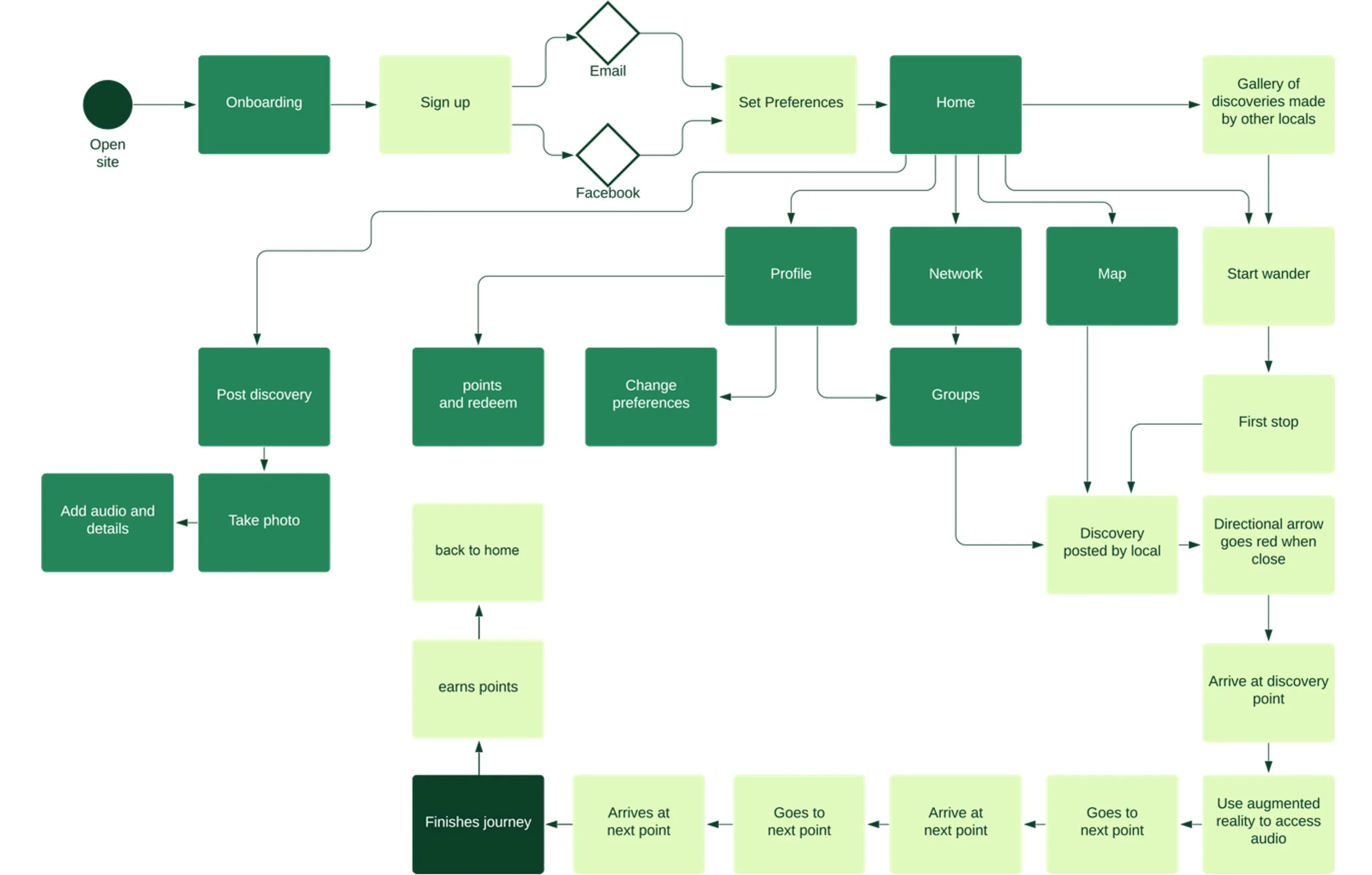
Task flow diagram
Paper Prototyping
Following on from initial sketching to test out the concept internally, a revised series of screens were sketched and were linked together to create a full paper prototype. It was important to test at this stage, the paper prototype, with at least one person who was unfamiliar with the project to validate the concept and to gain initial user feedback into how the experience could be progressed or developed.


The tester was asked two very simple tasks to validate the concept. These were to sign up with Facebook and to proceed through one walking journey. The tester was able to navigate through both tasks with ease. The paper prototype was a good tool to validate the approach in preparation for development and scaling of the artefact for testing amongst a bigger testing group.
Artefact iteration 1 - medium level
As the paper prototype had been tested and the concept validated, the next stage was to develop a Minimal Viable Product (MVP) which could expand on the app functionalities from the paper prototype. A working title of ‘Urban Wander’ was given to the walking app, It was decided a simple and clear name was the best approach to eliminate confusion and provide the most amount of clarity to the user. It was decided to include imagery at this stage to recreate as close to possible the real experience for the user. Due to timeframes it was decided to do further visual research and design development before testing.

Visual research and competitive analysis
Visual research provided opportunities to look at competitors and benchmark the potential User Interface design of the Urban Wander app against theirs.
For the Urban Wander app the nearest competitors would be Spotify, a music streaming app and Meetup, an app encourages people to meetup in mostly offline setting and build connections and community through common interests. Because the Urban Wander app is attempting to increase discovery and connection in the Rathmines area, referring to these apps provided valuable insights as these apps shared similar goals and appealed to a wide audience, as is the case in relation to this walking app.
Sports brands such as IRFU and Nike gave inspiration to tone and colour as this app should carry a tone of energy and activity as it will be used while exercising.

Design development
A colour palette of dark greens with brighter greens accents was decided as the appropriate direction to take. Green is a colour of nature and as a large portion of survey’s respondents cited nature as the best aspect of walking in the Rathmines area. It was also important to integrate natural colours into the User Interface design as it would help visually bridge their existing walking experience with a new walking experience


To evoke the sense of wonderment and exploration, a hand drawn style was decided upon for the logo identity. A hand drawn style would also differentiate itself from competitors such as Spotify who employ a more muted and clean typographic approach which doesn’t appeal to the adventurous nature of the Urban Wander app.
High Fidelity Prototype
A High Fidelity Prototype was developed for user testing incorporating imagery and colour and the newly developed identity.

Check
User testing
The first round of testing involved 3 testers and due to the COVID-19 pandemic all tests were conducted remotely with notes taken and scores for successful completion of tasks. A survey before and after tests were sent to gain further insights.
I conducted 7 tests:
1. Sign up with Facebook and go through the onboarding process.
2. Start a new walk
3. Play an audio file of a discovery made
4. Finish walk
5. Find artmines walking group
6. Take a photo of a discovery and upload
7. Find a discovery on the map

While the user tests garnered an average success rate, the post-test surveys had more favourable results. In relation to sense of belonging to the area, the app received a score of 7 out of 10. This compares to 5.5 in the pre-test survey and confirms a moderate improvement. When asked about how likely the app would increase their sense of connection to others in the area the scores increased from 3.75 to 7.75 represents a lower score than received in the initial research surveys so the increase before and after the test is quite notable. Noting limitations, these results shows encouraging signs that the walking app has the potential to affect a experience for local walkers.
Make again
Artefact 2 - high level
Taking into account the concerns and pain points users had while testing, and refining into a more developed high level prototype for a second round of testing, the hope was to discover more successful results in how the app could answer the research question.
One of the main limitations of the first iteration was the level of content included. A total of 9 points of interest plus one point of interest that a tester uploads as part of the test were created. It was decided in order to simulate the idea of a user being brought on a random wander of 3 points, that there would be a combination of 9 different routes of 3 points to select from the home screen.


Improvements to the UI were made and details were finessed in order to create the most enjoyable user experience possible. In particular improvements were made to the variety of colour used as one of the tester remarks that it was difficult to distinguish between buttons.
Check again
User testing
For the second test, a new set of 3 testers were asked again to complete a pre and post-test surveys as well as perform many of the same tasks as the previous round of testing. With the addition of more points of interest and more content in terms of textual and audio information, the testers in round 2 were asked in the pre-test additional local history questions to gauge their knowledge of 4 of the points included in the walking app prototype.
I conducted 9 tests in total:
1. Sign up with Facebook and go through the onboarding process.
2. Find a colourful building on home screen and start a walk there
3. Play an audio file of a discovery made on this walk
4. Note something interesting about each of the 3 points on this walk. Write/Say aloud
5. Finish walk and start another walk
6. Find 1 interesting fact on this walk you didn't know about before
7. Find artmines walking group
8. Take a photo of a discovery and upload
9. Find a discovery on the map
Overall the walking app in round 2 outperformed round 1 with a 94% success rate in task completion, a 37% increase on round 1. Assessing the three essential criteria of belonging, connection and awareness of local history, the app made significant improvements in all three of these categories. There was a 46.7% percent increase in potential of sense of belonging from before the test was completed, an 46.6% in potential sense of connection to others and a 63.4% increase in awareness of local history.


Reflection and Summary
The end result was a walking app that showed a huge amount of potential in creating a unique and enjoyable walking experience for locals in the Rathmines Area. When assessing the three main aspects of the research question, the ability for the walking app to increase discovery was most successful as the survey results returned a strong increase in historical knowledge from before the test.
The results, however encouraging and successful they were, can only give an indication of the strong potential and possible effect the walking app could have in increasing discovery and connection to the local area. The results could provide a solid foundation and validation for a full app development of the user experience. Using a larger sample size than featured in the scope of this research project and conducting a larger set of tests could create a tangible and real working app that could have the ability to increase people’s connection with their local urban space and the neighbours they share it with.